Welcome to IENC on the Cloud
 The U.S. inland navigation system consists of 8,200 miles of rivers maintained by the Corps of Engineers in 22 states, and includes 276 lock chambers with a total lift of 6,100 feet. The highly adaptable and effective system of barge navigation moves over 625 million tons of commodities annually, which includes coal, petroleum products, various other raw materials, food and farm products, chemicals, and manufactured goods (Reference Corps Navigation Data Center).
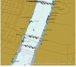
The shallow draft waterways have many unique characteristics and difficulties over coastal harbor and ocean navigation; river levels can change by over 30 feet in a seasonal cycle, the navigation channel can shift significantly within the river banks, and shifting yet ever present river currents pose constant challenges in these confined waterways. Electronic chart systems can offer significant benefits to vessels including accurate and real-time display of vessel position relative to waterway features, voyage planning and monitoring, training tools for new personnel and integrated display of river charts, radar, and Automatic Identification Systems.
 Following recommendations by the National Transportation Safety Board, the National Academy of Science and the American Waterways Operators, Congress directed the Corps of Engineers to develop and publish electronic charts for the inland waterways. Development of Inland Electronic Navigational Charts (IENCs) to cover the Mississippi River and tributaries thus began in 2001 with pilot projects on the Atchafalaya River in Louisiana and Lower Mississippi River near Vicksburg, Mississippi. These projects, which involved a combination of in-house and contract activities, were the first efforts to collect and convert inland waterway data, commonly used for river and channel maintenance, into the international S-57 hydrographic data exchange. This highly structured data format is commonly used for electronic chart applications and will be used for Corps IENCs.
Related Links